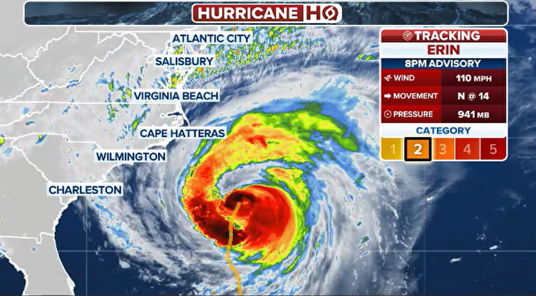
Hurricane Erin, now a Category 2 storm, is advancing toward North Carolina’s Outer Banks, causing worsening weather conditions. Officials have issued evacuation orders and warnings of tropical storm impacts, expecting heavy rains, strong winds, and flooding late Wednesday into Thursday.
Even without a likely direct landfall, the National Weather Service warns residents along the East Coast about life-threatening surf, large waves, and rip currents. Beaches from Florida up to New York have closed to swimmers, while New York City officials have shut down public beaches to avoid accidents. North Carolina’s Governor Josh Stein declared an emergency and warned residents of increasing storm surge, flooding, and beach erosion.
By Wednesday evening, rainbands from Erin reached the Outer Banks, bringing high winds and sea levels rising. Flooding eased briefly at low tide but will worsen with high tide on Thursday morning. Wave heights could reach 10 to 20 feet along the coast, with the Northeast facing swells up to 15 feet. Floodwaters covered areas like the Cape Hatteras Motel in Buxton, and flood damage closed parts of North Carolina Highway 12, the only road connecting islands. Officials urged drivers not to enter flooded areas with their repeated warning: “Turn around, don’t drown.”
Evacuations have started, especially on Ocracoke Island where thousands left by ferry. Ferry service continues until conditions worsen. Hatteras Island braces for severe impacts with concerns about rescue operations during the storm surge.
The storm’s wide reach impacts much of the Atlantic coast, generating rough surf and dangerous rip currents. The National Oceanic and Atmospheric Administration cautions that these currents can rapidly pull swimmers away from shore, prompting beach closures and warnings from New Jersey to Florida.
Higher sea levels today, compared to previous decades, make coastal regions more prone to storm damage. Kimberly McKenna from Stockton University noted that rising waters intensify erosion and flooding, compounding the effects of storms like Erin. The timing of the storm with high tides raises the risk of severe flooding.
Erin could strengthen briefly into a Category 3 hurricane between Bermuda and the U.S. East Coast in the coming 12-24 hours. High surf advisories affect the coast from Florida to Maine. Conditions are expected to improve by late Friday and Saturday as the storm moves offshore, but dangerous impacts will persist.
Governor Stein warned, “North Carolina faces serious risks from surf, surge, and flooding. This storm is not one to underestimate.” Officials urge residents to heed evacuation orders, avoid floodwaters, and focus on safety as the storm approaches.